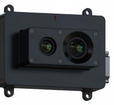
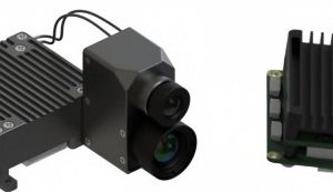
The VN-2 Image Matching Navigation Module provides visual positioning for UAVs in GNSS-denied environments, meeting the navigation and situational-awareness needs of flight vehicles when satellite signals are jammed or unavailable. Using map-matching principles, the module compares onboard camera imagery against reference maps to compute the vehicle’s position, and outputs spatial longitude and latitude via serial port to the navigation control system. A visible-light 1920×1080 camera is standard with an optional 640×512 infrared camera, both operating at 50 Hz for all-day capability. Positioning accuracy is 30 m or better (1σ) below 300 m flight altitude and within 5% of altitude up to 2000 m. Two RS232/UART ports handle communication with flight-control computers while an Ethernet port supports program updates, debugging and map data downloads. The module supports integration with external MEMS or fiber-optic IMUs for fully integrated navigation output of position, velocity and attitude. Compact (≤200 g) and low power (≤15 W), it is widely applicable across UAV systems.
Specifications
| Parameter | Value | Unit |
|---|---|---|
| Dimensions | 103×86×15 / 106×76×49 (customizable) | mm |
| Weight | ≤200 | g |
| Power supply | 12–32 V, ≤15 | W |
| Camera type | Visible light (standard) or infrared (optional) | – |
| Camera resolution | Visible 1920×1080; infrared 640×512 (optional) | pixels |
| Frame rate | 50 | Hz |
| Interface 1 | 2x RS232/UART for flight-control computers | – |
| Interface 2 | 1x Ethernet for updates, debugging, map downloads | – |
| Positioning accuracy | ≤30 m (altitude <300 m, 1σ); ≤5% of altitude (300–2000 m, 1σ) | – |
| Operating time | Available all day | – |
| Storage | 64/128/256 (optional) | GB |
| Integrated navigation | External MEMS or fiber-optic IMU support | – |
| Working temperature | −40 to +60 | °C |
Reviews
There are no reviews yet.